Storm Eowyn has hit the British Isles with hurricane-force winds as the tempest brings an ‘extreme and real’ threat to life, with some told to ‘shelter in place’.
Wind readings show southern and western Ireland bearing the early brunt of one of the strongest storms to ever hit thecountry.
Mace Head on the exposed Galway coast recorded a gust of 108mph at 4am, with figures of more than 80mph appearing widely. In Wales, Capel Curig in Snowdonia hit 88mph.
But gusts of 80 to 90mph are expected widely inland in the warning areas, with speeds of up 100mph likely to rip along coasts as the storm progresses.
Millions of people will be in the path of the maelstrom, which is predicted to become one of the most powerful weather systems to hit the UK in recent years.
Rare red warnings for wind have been issued by the Met Office in Northern Ireland from 7am until 2pm on Friday, and for western and central areas of Scotland between 10am and 5pm.
Winds reaching 60 to 70mph will be widespread in these warning areas.
RAC Breakdown advised motorists in warnings areas to stay safe by parking away from trees, keep a firm grip on the steering wheel, avoid coastal routes and watch out for debris.
Schools have been closed and people warned not to travel on Friday, as the expected 100mph winds pose a danger to life in parts of the UK.

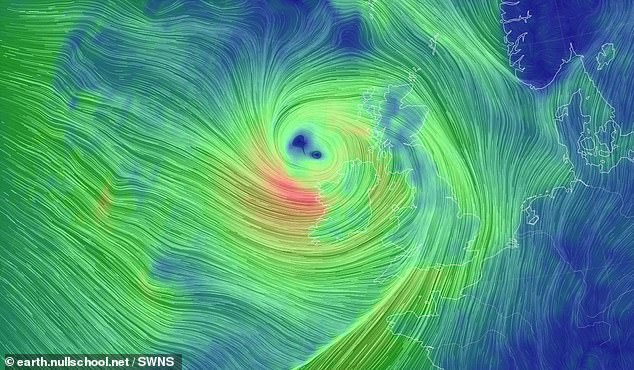
Forecasted path and wind strength of Storm Éowyn at 5am today

Scots brace for extreme weather conditions as the storm begins to batter the UK

A rare red weather warning has been issued by the Met Office for Storm Eowyn, warning of gusts of up to 100mph and ‘flying debris resulting in danger to life’

Preparations are underway in the town of Donaghadee on the Co Down coast line with sandbags at shop doors and signs up on shops ahead of Storm Eowyn
Public transport is at a halt amid powerful gusts with warnings of danger to life, fallen electric lines, damaged infrastructure and widespread power outages.
Police in Northern Ireland declared a major incident, and said they expect the strongest winds in the region since the Boxing Day storm in 1998 which caused widespread disruption.
Train operator ScotRail has suspended all services across Scotland on Friday, saying it ‘would not be safe to operate passenger services due to forecast weather conditions’.
A number of train companies including Avanti West Coast, Lumo, CrossCountry and Grand Central have also told customers not to travel on routes across parts of north Wales, Scotland and northern England with no services running.
Glasgow and Edinburgh Airport said they were limiting airport operations on Friday, with the former citing a ‘significant level of flight cancellations’ while Belfast International warned of significant disruption to flights.
Speaking to media in Belfast on Thursday afternoon First Minister Michelle O’Neill and deputy First Minister Emma Little-Pengelly urged people to stay at home where they can and check in on vulnerable people.
‘A red alert has been issued for the entire of Northern Ireland,’ Ms Pengelly said.
‘This is highly unusual, this means between 7am and 2pm tomorrow there is a likelihood of widespread disruption, danger to life and damage to buildings, and our strong advice and the advice of the PSNI is to stay at home if at all possible.’
Meanwhile, the chairman of Ireland’s National Emergency Co-ordination Group, Keith Leonard, said Storm Eowyn will be one of the most severe storms Ireland has seen.
‘It is going to be a damaging, dangerous and destructive weather event,’ he said in Dublin on Friday.

A road sign displaying a red weather warning for Friday on Calder Road, Edinburgh


Other people are making sure their bins won’t blow away in the 100mph winds

Some shoppers have stockpiled basics to prepare for the incoming storm

Trees have been blown down in Kerry during Storm Eowyn
‘The forecasted winds will bring severe conditions which will constitute a risk to life and property.
‘Our most important message today is that everybody needs to shelter in place for the duration of all red warnings.
‘We are likely to see significant and widespread power outages, so I would encourage everyone to prepare ahead. Make sure phones, torches and laptops are fully charged.’
The coastal town of Donaghadee in Co Down was among those making preparations on Thursday night.
Some businesses placed sandbags at their doors, while others displayed signs to say they would be closed until after the red level alert expires on Friday afternoon.
Nearly five million people received a government emergency alert on their phones last night in the ‘largest real life use of the tool to date’.
Some businesses placed sandbags at their doors, while others displayed signs to say they would be closed until after the red level alert expires on Friday afternoon.
It played a loud siren sound for 10 seconds, even on phones which were on silent, and included information about the weather warnings and advice on how to stay safe.
The chairman of the National Emergency Co-ordination Group, Keith Leonard, said that Storm Eowyn will be one of the most severe storms Ireland has seen.
‘It is going to be a damaging, dangerous and destructive weather event,’ he said in Dublin on Friday.
Eoin Sherlock, head of forecasting at Met Eireann, said red nationwide warnings have been issued because of the ‘extraordinary intensity’ of the storm.
‘The storm is going to approach the south-west coast early tonight, and it will spread northwards through the country.
‘We expect this storm to be destructive, dangerous and disruptive. We can expect (gusts) greater than 130 kilometres per hour inland, which is very, very unusual.’
The season’s fifth named storm could be so bad that BBC weather presenter Judith Ralston said: ‘This is one major storm. I’ve not seen anything like it in my career.’
Another weather expert warned that Storm Eowyn could bring the lowest pressure to Scotland since 1982, making it one of the ‘most intense’ storms to hit the country in recent history.
Forecasters even warned pet owners to keep their dogs on leads amid fears they could be swept away by strong waves on the coast.
In a statement at the Scottish Parliament, First Minister John Swinney said: ‘The storm could bring winds up to 100mph.

Storm Eowyn appears to have hit Cornwall – as a mini ‘tornado’ left a trail of destruction

Aftermath as Storm Eowyn hits Quintrell Downs in Cornwall on January 23
‘The Met Office advice is clear, the potential impacts include danger to life, structural damage to property and transport and power disruptions.
‘We have to be clear, people should not travel.
‘Our message is simple, please follow the advice from the Met Office and the police, take this seriously and stay safe.’
Mr Swinney chaired a meeting of the Scottish Government Resilience Room – Scotland’s answer to Cobra – on Thursday afternoon, and cancelled a planned visit to the A&E department at Ninewells Hospital in Dundee on Friday.
The Scottish Parliament itself will be closed all day on Friday because of the storm, with only essential staff on site.
Scotland’s Transport Secretary Fiona Hyslop warned of ‘widespread disruption to the transport network’.
She said: ‘I would urge people to follow police advice and avoid travel in the area affected by the red warning for wind. If you do need to travel, your journey is likely to be badly disrupted and there will likely be cancellations to rail, ferry and air services.’
West coast ferry operator CalMac cancelled all services across its network.
Forecast winds of 80mph around the Forth bridges would close the Forth Road Bridge, road management firm Bear Scotland said.
The Queensferry Crossing and Clackmannanshire Bridge would be closed to high-sided vehicles, motorcycles and cars with trailers or roof boxes in these circumstances.
The National Trust for Scotland said many of its attractions would be closed on Friday and Saturday and Historic Environment Scotland said several castles will close, including Edinburgh and Stirling.
Source link


